

|
~
|
 The S5PVAL-BE campaign Sentinel-5 Precursor (S-5P), launched in October 2017, is the first mission of the Copernicus Programme dedicated to the monitoring of air quality, climate, ozone and UV radiation. Its characteristics, such as the fine spatial resolution, introduce many new opportunities and challenges, requiring to carefully assess the quality and validity of the generated data products by comparison with independent measurements and analyses. A series of campaign activities have been identified in the ESA S-5P Campaign Implementation Plan, established to address key validation priorities. On this basis, an S-5P validation campaign over Belgium (S5PVAL-BE), focusing on airborne nitrogen dioxide (NO2) column observations, was identified as having high potential and high priority due to (1) the steep gradients in the NO2 field over key Belgian cities, (2) the expertise built during the precursor BUMBA campaigns over Belgium and (3) the availability of airborne prism experiment (APEX) and complementary ground-based infrastructures, such as Mobile-DOAS, MAX-DOAS, and CIMEL stations.
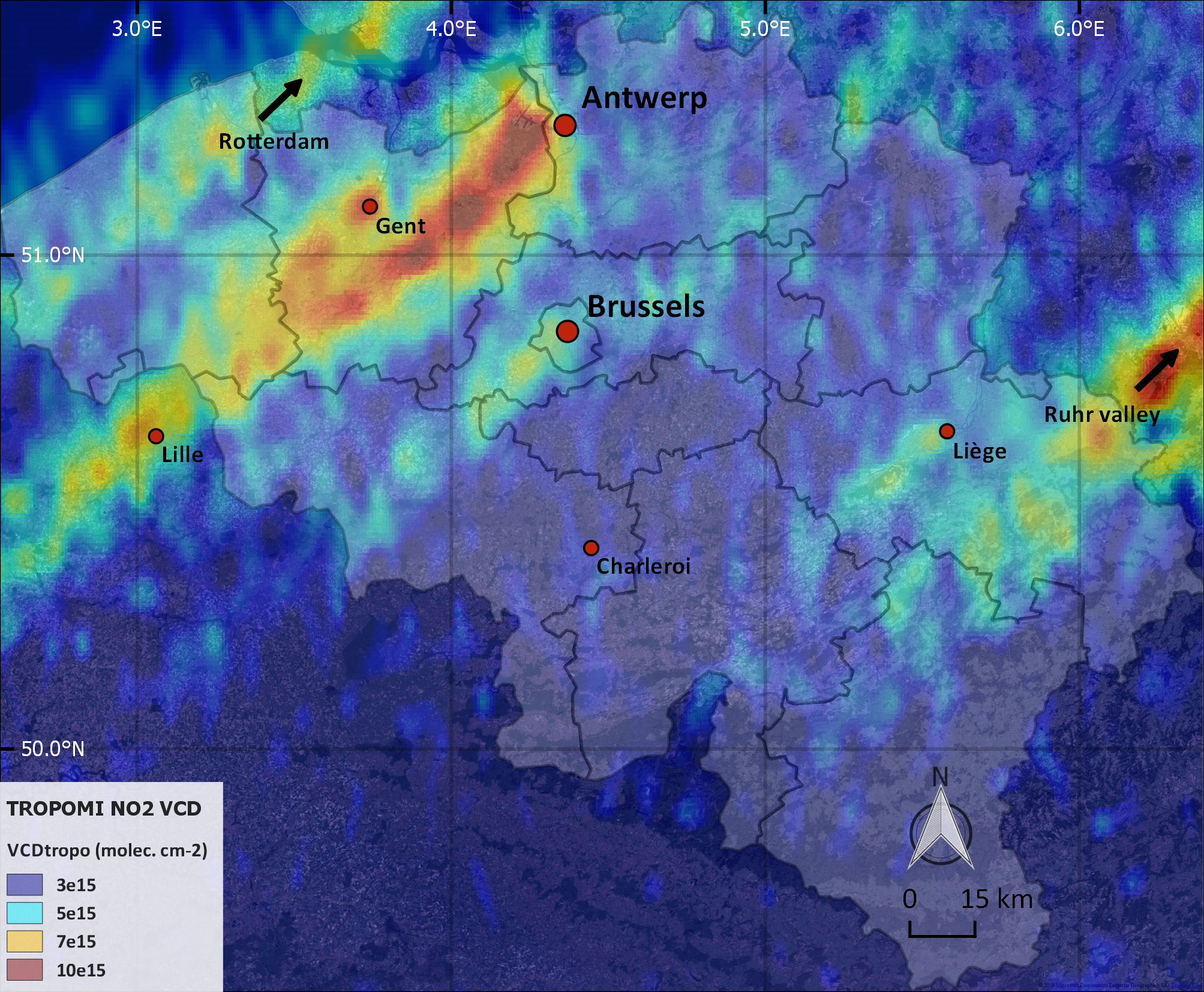
Figure 1. Tropospheric NO2 hotspots, observed over Belgium by TROPOMI based on a early afternoon S-5P orbit on 27 June 2019 (Google, TerraMetrics). The S5PVAL-BE campaign took place from 26 to 29 June, 2019 over Antwerp and Brussels, Belgium, to map the horizontal distribution of tropospheric NO2. In total four mapping flights took place on four consecutive, cloud-free days with the APEX imaging spectrometer, operated by the Flemish Institute for Technological Research (VITO). Mapping flights were scheduled to take place within one hour of the S5-P overpass.
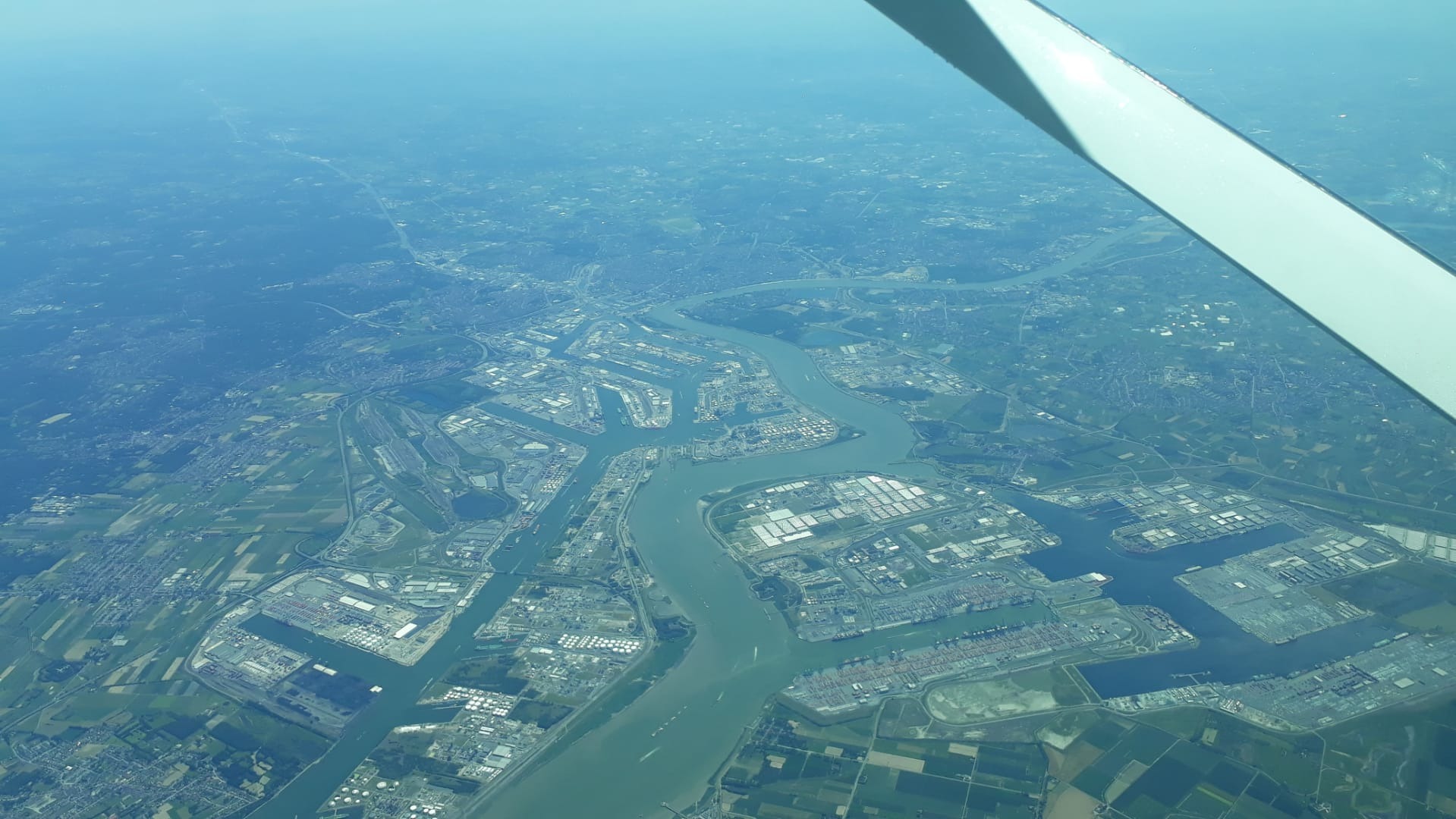
Figure 2. Picture of the Antwerp harbour and river Scheldt acquired during a mapping flight of the Cessna 208B Grand Caravan EX, owned by Swiss Flight Services (SFS). Picture taken by APEX operator Bart Bomans (VITO). The study will focus on the assessment of the TROPOMI level-2 tropospheric NO2 product over strongly polluted regions, and more specifically on the accuracy and precision of the retrieved vertical column densities (VCDs), and intermediate products. Airborne remote sensing instruments, such as APEX, able to map the NO2 distribution at a sufficiently high resolution (1) to capture the strong gradients and (2) to resolve individual emission sources are considered to be a very valuable source of data for satellite validation. The very high resolution APEX airborne observations (~60 x 80 m2) are also a unique data set allowing to study the NO2 spatial distribution and the TROPOMI subpixel variability, as well as the impact of spatial smoothing of the signal due to the finite satellite pixel size of TROPOMI (3.5 x 7 km2 at nadir), typically larger than the fine-scale structures in heterogeneous city plumes. The acquired data is currently being processed and analysed. Publications Tack, F., Van Roozendael, M., Merlaud, A., Sha, M. K., De Mazière, M., Richter, A., Meier, A., Bovensmann, H., Apituley, A., Hase, F.: S-5P Campaign Implementation Plan, Issue 1, Royal Belgian Institute for Space Aeronomy (BIRA). Acknowledgements and links The Belgian Federal Science Policy Office is gratefully appreciated for funding the APEX aircraft activities over Belgium, performed by VITO, in the framework of the STEREO programme.
Contact For more information, please contact : Frederik Tack or Alexis Merlaud or Michel Van Roozendael |


Last update on 09 Aug 2019