

|
~
|
 Belgian Urban NO2 Monitoring Based on APEX remote sensing The BELSPO funded BUMBA project (Belgian Urban NO2 Monitoring Based on APEX remote sensing), which is a collaboration between BIRA-IASB, VITO and IRCEL-CELINE, started in January 2015. A major objective is to assess the technical and operational capabilities of the airborne APEX sensor for DOAS-based (Differential Optical Absorption Spectroscopy) atmospheric trace gas retrieval. The Airborne Prism EXperiment (APEX) instrument is a pushbroom hyperspectral imager with a high spatial resolution of approximately 3 m, a swath width of 3000 m at a typical altitude of 6000 m AGL and high spectral performance (See Table 1). It is developed by a Swiss-Belgian consortium on behalf of ESA (European Space Agency) and initially designed for land use / land cover remote sensing applications.
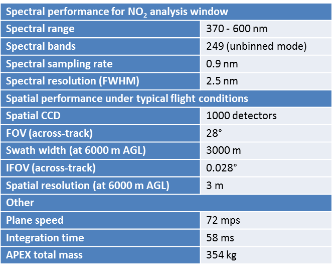
Table 1. APEX spectral and spatial performance The project aims at the development of an algorithm to retrieve tropospheric nitrogen dioxide (NO2) vertical column densities (VCDs) from the APEX spectra, being solar radiation backscattered by the atmosphere or ground surface, and to map the NO2 spatial distribution at high resolution (See Figure 1). The NO2 VCDs retrieved from APEX spectra will be used in a next step for validation and improvement of the high resolution RIO-IFDM air quality model, recently developed by VITO and IRCEL-CELINE. NO2 is an atmospheric trace gas, with a substantial impact on tropospheric chemistry, climate and human health, and often studied as a proxy for air pollution in general. It is a key pollutant emitted in Belgium. The RIO-IFDM model aims at informing in near-real time on the risk of human exposure to NO2.
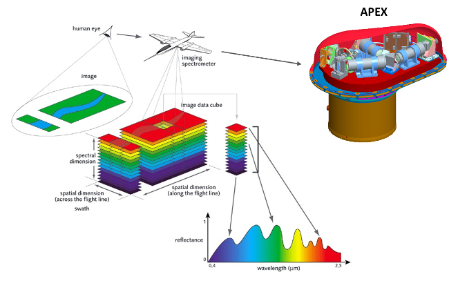
Fig 1. APEX hyperspectral imaging of the Earth’s surface On April 14-15 and June 30, 2015, a flight campaign is carried out over the three largest and most heavily polluted Belgian cities, i.e. Brussels, Antwerp and Liège in order to map the NO2 spatial distribution. APEX was mounted in a Dornier DO-228 airplane, operated by Deutsches Zentrum für Luft- und Raumfahrt (DLR).
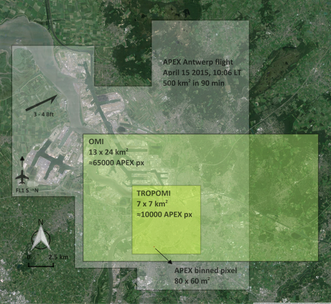
Fig 2. APEX flightplan over Antwerp on April 15, 2015 and comparison with a typical spaceborne OMI and TROPOMI pixel Main sources in the Antwerp area are related to (petro)chemical industry (see Figure 3). The NO2 levels range between 3 and 35 x 1015 molec cm-2, with a mean of 1.6 x 10¹⁶ molec cm-2. The detection limit has a typical value between 1.7 and 2.2 x 10¹⁵ molec cm-2 on the VCD. The NO2 levels in the Brussels area (see Figure 4) have minima and maxima of 1.6 and 22 x 1015 molec cm-2, respectively and a mean VCD of 6.5 x 10¹⁵ molec cm-2. The NOx sources are mainly originating from traffic here. Results demonstrate that the NO2 distribution in an urban environment, and its fine scale variability, can be mapped accurately with high spatial resolution and in a relatively short time frame, and the contributing emission sources can be resolved.

Fig 3. Retrieved NO2 VCD distribution map for Antwerp (April 15, 2015).

Fig 4. Retrieved NO2 VCD distribution map for Brussels (June 30, 2015). The retrieved NO2 columns are compared with coincident static and car-based MAX-DOAS observations. More information on the car-based mobile-DOAS activities of BIRA-IASB can be found here. Both data sets are in good agreement with correlation coefficients around 0.85 and slopes close to unity. APEX retrievals tend to be on average 12 % and 6 % higher for Antwerp and Brussels, respectively.
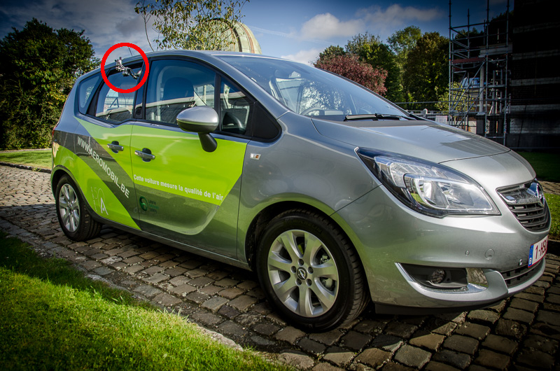
Fig 4. The BIRA-IASB Aeromobil used for car-based MAX-DOAS observations. The optical head with a zenith and 30° degrees dual channel is connected with the spectrometers and acquisition pc through optical fibers. Publications Tack, F., Merlaud, A., Iordache, M.-D., Danckaert, T., Yu, H., Fayt, C., Meuleman, K., Deutsch, F., Fierens, F., and Van Roozendael, M.: High-resolution mapping of the NO2 spatial distribution over Belgian urban areas based on airborne APEX remote sensing, Atmos. Meas. Tech., 10, 1665-1688, 2017, https://doi.org/10.5194/amt-10-1665-2017 Acknowledgements and links The BUMBA project is funded through the STEREO III Research Programme for Earth Observation (SR/00/310) of the Belgian Federal Science Policy Office and is a collaboration between BIRA-IASB, the Flemish Institute for Technological Research (VITO) and the Belgian Interregional Environment Agency (IRCEL-CELINE).
Contact For more information, please contact : Frederik Tack or Michel Van Roozendael |


Last update on 09 Aug 2019