

|
~
|

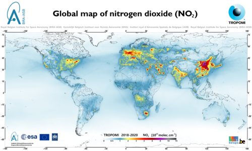
The Copernicus Sentinel-5 Precursor (S-5P) satellite was launched in October 2017 and its onboard instrument TROPOMI has delivered many impressive views of the distribution of atmospheric constituents that are relevant to air quality and climate. Based on the results, UV-VIS retrieval experts at BIRA-IASB have produced high resolution global maps for the molecules nitrogen dioxide (NO2), sulphur dioxide (SO2), formaldehyde (HCHO) and glyoxal (CHOCHO). The maps show a wide range of natural and anthropogenic sources, mapped with more detail than ever before, due to TROPOMI's enchanced sensitivity and spacial resolution. The maps can be freely downloaded and used without any restriction for non-commercial applications, excluding scientific publications. In case of public presentation of any kind (e.g. poster or talk), adequate credit to the UV-VIS Remote Sensing group of the Royal Belgian Institute for Space Aeronomy (BIRA-IASB) must be given.
Download the maps
A4 size PNG (29.7 cm × 21 cm) with source information
Image sizes in cm are based on 300 DPI resolution. |
|||||


Last update on 13 Apr 2021